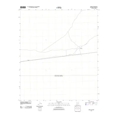
2010 Map of Noria
USGS Topo · Published 2010About this map
Noria serves as a central reference point in this arid borderland survey, situated just north of the international boundary between the United States of America and Estados Unidos Mexicanos. The landscape is characterized by its stark utility and sparse settlement, with infrastructure largely defined by the presence of County Rd-A003 and its various branches. To the east, Herrington's Lower Ranch provides a specific look at the rural landholdings in Doña Ana County during the early 21st century. The map illustrates a transitional desert environment where the straight-line geometry of the international border meets the winding paths of local ranch roads, reflecting the isolated nature of this section of the New Mexico borderlands.
Find a feature on this map
4 named features on this map. Tap any name to fly to it.
Don’t see what you’re looking for? This feature index may not catch every label — zoom into the map to look around manually.
Map Details
Editions of this 2010 Noria Map
This is the sole edition of this map. No revisions or reprints were ever made.
Other maps of this area

1917 · Canutillo
USGS Topo · 1:62,500

1917 · Noria
USGS Topo · 1:62,500

1918 · Noria
USGS Topo · 1:62,500

1919 · Canutillo
USGS Topo · 1:62,500

1953 · El Paso
USGS Topo · 1:250,000
1955 · Strauss
USGS Topo · 1:24,000
1955 · La Union
USGS Topo · 1:24,000

1959 · El Paso
USGS Topo · 1:250,000

1964 · El Paso
USGS Topo · 1:250,000

1965 · El Paso
USGS Topo · 1:250,000