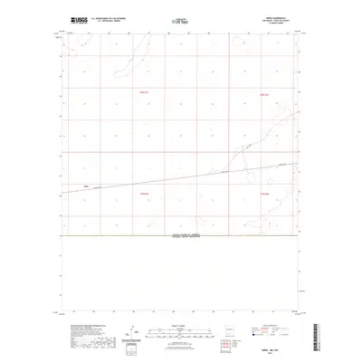
2023 Map of Noria
USGS Topo · Published 2023About this map
Noria sits in the high desert of Doña Ana County, marking a sparse settlement area defined by its proximity to the international boundary. The landscape is dominated by the United States of America Estados Unidos Mexicanos border, which runs along the southern edge of this modern survey. The passage of A003 Co Rd provides the primary transit corridor through the arid terrain, connecting the isolated interior of the Chihuahuan Desert to the broader regional network. The map reveals a land divided by the Public Land Survey System, with township boundaries like t29s r1e and t28s r2e carving the open range into a geometric grid that belies the fluid, shifting nature of the desert floor.
Find a feature on this map
8 named features on this map. Tap any name to fly to it.
Don’t see what you’re looking for? This feature index may not catch every label — zoom into the map to look around manually.
Map Details
Editions of this 2023 Noria Map
This is the sole edition of this map. No revisions or reprints were ever made.
Other maps of this area

1917 · Canutillo
USGS Topo · 1:62,500

1917 · Noria
USGS Topo · 1:62,500

1918 · Noria
USGS Topo · 1:62,500

1919 · Canutillo
USGS Topo · 1:62,500

1953 · El Paso
USGS Topo · 1:250,000
1955 · Strauss
USGS Topo · 1:24,000
1955 · La Union
USGS Topo · 1:24,000

1959 · El Paso
USGS Topo · 1:250,000

1964 · El Paso
USGS Topo · 1:250,000

1965 · El Paso
USGS Topo · 1:250,000