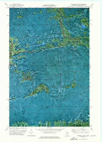
1973 Map of Norman Lake SE
USGS Topo · Published 1976About this map
Pine Island State Forest dominates this northern Minnesota landscape, where the seasonal movement across the wetlands of Koochiching County is captured in the network of a Winter Trail. Published in the mid-1970s from aerial photography, this orthophotomap provides a distinct perspective on the hydrologic patterns of the region, specifically where the Tamarac River and Lost River navigate through the dense forest and peatlands. The absence of permanent road infrastructure highlights the reliance on winter routes for accessing the interior, illustrating a landscape where transportation was historically governed by the freeze. These surveys are essential for understanding the environmental geography of the borderlands before modern drainage or development patterns altered the natural flow of these isolated waterways.
Find a feature on this map
5 named features on this map. Tap any name to fly to it.
Don’t see what you’re looking for? This feature index may not catch every label — zoom into the map to look around manually.
Map Details
Editions of this 1973 Norman Lake SE Map
This is the sole edition of this map. No revisions or reprints were ever made.
Other maps of this area

1919 · Lundgren
USGS Topo · 1:62,500

1919 · Gemmell
USGS Topo · 1:62,500

1919 · Norden
USGS Topo · 1:62,500

1919 · Bridgie
USGS Topo · 1:62,500

1924 · Bridgie
USGS Topo · 1:62,500

1954 · Bemidji
USGS Topo · 1:250,000

1954 · Roseau
USGS Topo · 1:250,000

1957 · Roseau
USGS Topo · 1:250,000

1957 · Bemidji
USGS Topo · 1:250,000

1958 · Bemidji
USGS Topo · 1:250,000