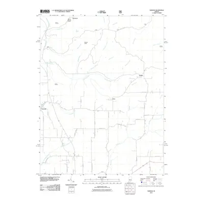
2010 Map of Norman
USGS Topo · Published 2010About this map
Heltonville and Norman anchor this landscape in south-central Indiana, where rural settlements are connected by a network of named county roads. The terrain is defined by a dense system of seasonal and year-round watercourses, including Leatherwood Creek and its southern fork, as well as Henderson Creek and Hunter Creek. Genealogists will find significant value in the documentation of family-named landmarks like Mitchell Ridge and Dennis Murphy Hollow, alongside local burial grounds such as Callahan Cemetery and Faubion Cemetery. The placement of Mundell Church at the intersection of Mundell Church Rd and Fairview-Mundell Rd reflects the importance of small community hubs in the regional social structure. This documentation from the early 21st century highlights the persistent rural character of the area around Zelma and Yellowstone.
Find a feature on this map
44 named features on this map. Tap any name to fly to it.
Don’t see what you’re looking for? This feature index may not catch every label — zoom into the map to look around manually.
Map Details
Editions of this 2010 Norman Map
This is the sole edition of this map. No revisions or reprints were ever made.
Other maps of this area

1934 · Bedford
USGS Topo · 1:48,000

1937 · Bedford
USGS Topo · 1:62,500

1942 · Franklin
USGS Topo · 1:125,000

1947 · Allens Creek
USGS Topo · 1:24,000

1947 · Elkinsville
USGS Topo · 1:24,000
1950 · Elkinsville
USGS Topo · 1:24,000

1953 · Indianapolis
USGS Topo · 1:250,000

1956 · Indianapolis
USGS Topo · 1:250,000

1956 · Story
USGS Topo · 1:24,000

1956 · Vincennes
USGS Topo · 1:250,000