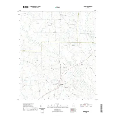
2020 Map of Norman Park
USGS Topo · Published 2020About this map
Norman Park and the nearby community of Crosland anchor this Colquitt County landscape, where the agricultural grid is defined by a dense network of family-named roads. The terrain is deeply tied to the drainage systems of Warrior Creek and its tributaries, including Lolly Creek and Reedy Creek. Numerous small lakes, such as Gray Lake, Willis Lake, and Hall Lake, dot the area between the primary settlements. Genealogists will find significant value in the concentration of local burial grounds, including the Rocky Creek Church Cem, Deep Bottom Cemetery, and Sandy Ridge Cemetery. These landmarks, along with roads like Saunders Rd and Gene Hartsfield Rd, reflect the generations of family residency and land use across this South Georgia region.
Find a feature on this map
93 named features on this map. Tap any name to fly to it.
Don’t see what you’re looking for? This feature index may not catch every label — zoom into the map to look around manually.
Map Details
Editions of this 2020 Norman Park Map
This is the sole edition of this map. No revisions or reprints were ever made.
Other maps of this area

1953 · Waycross
USGS Topo · 1:250,000

1956 · Doerun
USGS Topo · 1:62,500

1958 · Waycross
USGS Topo · 1:250,000

1973 · Ty Ty
USGS Topo · 1:24,000

1973 · Norman Park
USGS Topo · 1:24,000

1973 · Tifton West
USGS Topo · 1:24,000

1973 · Omega
USGS Topo · 1:24,000
1974 · Tempy
USGS Topo · 1:24,000
1974 · Sigsbee
USGS Topo · 1:24,000

1974 · Pineboro
USGS Topo · 1:24,000