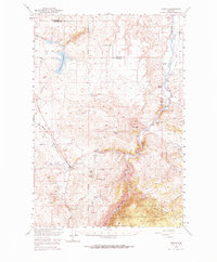
1949 Map of Norris
USGS Topo · Published 1967About this map
Norris serves as the central hub of this post-war ranching and mining landscape, situated at the confluence of several vital water sources and the Northern Pacific railroad line. The map captures a transitional moment in Madison County, where industrial activity is represented by several dormant operations such as the Waterhole Mine and Boaz Mine, pointing to an earlier era of mineral extraction. The social and agricultural fabric of the region is anchored by family landmarks like the Noble Ranch and Denike Ranch, while the Cherry Creek School and Red Bluff Cem mark the community's established roots. The geography is defined by the significant flow of the Madison River and the engineering of the Willow Creek Reservoir, alongside numerous irrigation features like the Upper Ditch and Lower Ditch that sustained the local valley economy.
Find a feature on this map
37 named features on this map. Tap any name to fly to it.
Don’t see what you’re looking for? This feature index may not catch every label — zoom into the map to look around manually.
Map Details
Editions of this 1949 Norris Map
2 editions found
Other maps of this area

1888 · Three Forks
USGS Topo · 1:250,000

1894 · Three Forks
USGS Topo · 1:250,000

1895 · Three Forks
USGS Topo · 1:250,000

1947 · Bozeman
USGS Topo · 1:250,000

1948 · Bozeman
USGS Topo · 1:250,000

1949 · Anceney
USGS Topo · 1:62,500

1949 · Manhattan
USGS Topo · 1:62,500

1949 · Ennis
USGS Topo · 1:62,500

1949 · Norris
USGS Topo · 1:62,500

1950 · Three Forks
USGS Topo · 1:62,500