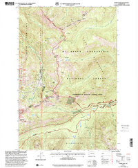
2000 Map of Norse Peak
USGS Topo · Published 2001About this map
The Pacific Crest National Scenic Trail winds through this high-elevation landscape along the boundary between Pierce and Yakima Counties. This area is characterized by a dense network of mountain passes and basins, including Pickhandle Gap, Sourdough Gap, and Bullion Basin. Evidence of early 20th-century exploration is scattered across the terrain, with several Mines and prospects located near Morse Creek. Recreation and conservation efforts are prominent, as the land is shared between the Mt Baker-Snoqualmie National Forest and the William O Douglas Wilderness. Significant water features like the American River and alpine lakes such as Goat Lake and Elizabeth Lake define the drainage patterns of this protected mountain environment.
Find a feature on this map
45 named features on this map. Tap any name to fly to it.
Don’t see what you’re looking for? This feature index may not catch every label — zoom into the map to look around manually.
Map Details
Editions of this 2000 Norse Peak Map
This is the sole edition of this map. No revisions or reprints were ever made.
Other maps of this area

1901 · Snoqualmie Pass
USGS Topo · 1:125,000

1902 · Mount Aix
USGS Topo · 1:125,000

1903 · Snoqualmie
USGS Topo · 1:125,000

1904 · Mt Aix
USGS Topo · 1:125,000

1913 · Cedar Lake
USGS Topo · 1:125,000

1924 · Mt Rainier
USGS Topo · 1:96,000

1928 · Mt Rainier
USGS Topo · 1:125,000

1950 · Yakima
USGS Topo · 1:250,000

1956 · Greenwater
USGS Topo · 1:62,500

1957 · Wenatchee
USGS Topo · 1:250,000