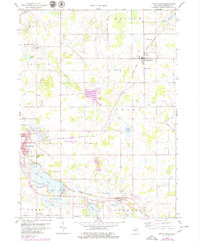
1959 Map of North Adams
USGS Topo · Published 1979About this map
The village of North Adams and the eastern edge of Hillsdale anchor this detailed look at rural Michigan at the end of the 1950s. The landscape is defined by its glacial history, featuring a chain of lakes including Baw Beese Lake, First Lake, and Second Lake that transition into the Hillsdale Municipal Airport grounds. Evidence of the region's shifting transportation and industry is visible in the corridor of the New York Central Abandoned railroad line, which once cut a diagonal path across the terrain near Lake Adams. Smaller hamlets like Osseo and Steamburg appear alongside local landmarks such as Stone Sch and several country burial grounds, including Mt Pleasant Cem and North Lawn Cem. The map also captures the early development of local recreation at the Hillsdale Country Club, situated along the lakefront before later 20th-century expansions.
Find a feature on this map
50 named features on this map. Tap any name to fly to it.
Don’t see what you’re looking for? This feature index may not catch every label — zoom into the map to look around manually.
Map Details
Editions of this 1959 North Adams Map
3 editions found
Other maps of this area

1935 · Jackson
USGS Topo · 1:48,000

1939 · Jackson
USGS Topo · 1:62,500

1948 · Spring Arbor
USGS Topo · 1:62,500

1949 · Spring Arbor
USGS Topo · 1:62,500

1953 · Fort Wayne
USGS Topo · 1:250,000

1956 · Fort Wayne
USGS Topo · 1:250,000

1958 · Grand Rapids
USGS Topo · 1:250,000

1959 · Hillsdale
USGS Topo · 1:24,000

1959 · Reading
USGS Topo · 1:24,000

1959 · North Adams
USGS Topo · 1:24,000