
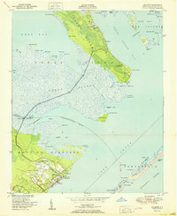
1948 Map of North Bay
USGS Topo · Published 1976About this map
Cedar Island and the marshy expanses of Hog Island define this coastal landscape as it was documented in the late 1940s. Situated between West Bay and the open Pamlico Sound, the area is characterized by a network of intricate waterways including Snake Gut, Deep Slough, and Fullers Ditch. The small settlement of Goodwin Hills sits near the southern edge, connected by the lone terrestrial corridor of Cedar Island Road. This survey, compiled from 1946 aerial photography, captures a transitional coastal environment where landmarks like Sandy Landing and Point of Grass provided essential orientation for local mariners and residents. The layout of the islands, including Hunting Island and Beach Island, shows the natural fragmentation of the shoreline before significant modern development altered these low-lying landforms.
Find a feature on this map
27 named features on this map. Tap any name to fly to it.
Don’t see what you’re looking for? This feature index may not catch every label — zoom into the map to look around manually.
Map Details
Editions of this 1948 North Bay Map
This is the sole edition of this map. No revisions or reprints were ever made.
Other maps of this area

1949 · Atlantic
USGS Topo · 1:24,000

1949 · Point Of Marsh
USGS Topo · 1:24,000

1949 · Long Bay
USGS Topo · 1:24,000

1950 · Long Bay
USGS Topo · 1:24,000

1950 · North Bay
USGS Topo · 1:24,000

1950 · Point Of Marsh
USGS Topo · 1:24,000
1951 · Atlantic
USGS Topo · 1:24,000

1951 · Brant Island
USGS Topo · 1:24,000

1953 · Rocky Mount
USGS Topo · 1:250,000

1953 · Beaufort
USGS Topo · 1:250,000