
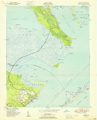
1950 Map of North Bay
USGS Topo · Published 1950About this map
Cedar Island and Hog Island define this coastal landscape where the waters of Pamlico Sound meet the marshy edges of Carteret County. The map captures a fragile geography of sand and salt marsh shortly after the mid-century, detailing tidal features like Snake Gut and End of Island Slough. Landmarks such as the Goodwin Hills and Point of Grass indicate the subtle elevations that guided local navigation and land use. This survey, compiled from 1946 aerial photography, documents the intricate shoreline of West Bay and North Bay before modern coastal changes, preserving the locations of historical points such as Sandy Landing and Waterbush Pt. The geography of Back Bay and narrow channels like The Passage illustrate the maritime character of this remote Carolina sound environment.
Find a feature on this map
25 named features on this map. Tap any name to fly to it.
Don’t see what you’re looking for? This feature index may not catch every label — zoom into the map to look around manually.
Map Details
Editions of this 1950 North Bay Map
This is the sole edition of this map. No revisions or reprints were ever made.
Other maps of this area

1948 · North Bay
USGS Topo · 1:24,000

1949 · Atlantic
USGS Topo · 1:24,000

1949 · Point Of Marsh
USGS Topo · 1:24,000

1949 · Long Bay
USGS Topo · 1:24,000

1950 · Long Bay
USGS Topo · 1:24,000

1950 · Point Of Marsh
USGS Topo · 1:24,000
1951 · Atlantic
USGS Topo · 1:24,000

1951 · Brant Island
USGS Topo · 1:24,000

1953 · Rocky Mount
USGS Topo · 1:250,000

1953 · Beaufort
USGS Topo · 1:250,000