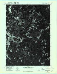
1977 Map of North Berwick
USGS Topo · Published 1979About this map
North Berwick and its surrounding rural corridors appear in this late-1970s orthophotograph, captured by aerial imagery on April 1, 1977. The map provides a photographic perspective of the landscape's transition from the dense woodlands characteristic of York County to the cleared fields and crossroads of established settlements. Significant local junctions include Parsonage Corner and Grays Corner, which mark the intersection of farm roads and homesteads within the coastal Maine interior. The imagery also documents industrial footprints, notably at Works near the western edge. Unlike traditional topographic maps, this rectified photoimagery shows the actual vegetation patterns and field boundaries as they existed during the spring thaw of 1977, offering researchers a look at land use near Pine and the northern reaches of Ogunquit.
Find a feature on this map
7 named features on this map. Tap any name to fly to it.
Don’t see what you’re looking for? This feature index may not catch every label — zoom into the map to look around manually.
Map Details
Editions of this 1977 North Berwick Map
This is the sole edition of this map. No revisions or reprints were ever made.
Other maps of this area

1891 · Berwick
USGS Topo · 1:62,500

1891 · Kennebunk
USGS Topo · 1:62,500

1893 · Kennebunk
USGS Topo · 1:62,500

1893 · Dover
USGS Topo · 1:62,500

1893 · Berwick
USGS Topo · 1:62,500

1893 · York
USGS Topo · 1:62,500

1898 · Kennebunk
USGS Topo · 1:62,500

1916 · Dover
USGS Topo · 1:62,500

1918 · Dover
USGS Topo · 1:62,500

1920 · York
USGS Topo · 1:62,500