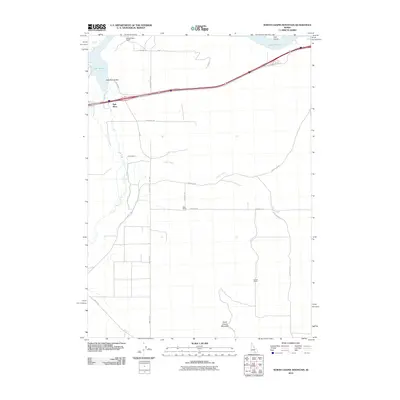
2010 Map of North Chapin Mountain
USGS Topo · Published 2010About this map
North Chapin Mountain anchor the southern reaches of this landscape, where the high desert meets the irrigated plains of the Raft River Valley. The northern border is defined by the waters of Lake Walcott, featuring Tule Island, while the Raft River itself winds northward through a network of rural access roads. This 2010 survey illustrates the persistent ranching character of the region, identifying established family operations such as Fenstermaker Ranch, Rehn Ranch, and Jensen Ranch. A grid of section roads like 2950 East Rd and Gifford Springs Rd connects these agricultural hubs, while Old U.S. Hwy 30 traces a legacy transportation route through the valley. The map documents the intricate drainage of Calder Creek as it feeds toward the larger river system, providing a precise look at the land use and water management in this portion of Cassia County.
Find a feature on this map
26 named features on this map. Tap any name to fly to it.
Don’t see what you’re looking for? This feature index may not catch every label — zoom into the map to look around manually.
Map Details
Editions of this 2010 North Chapin Mountain Map
This is the sole edition of this map. No revisions or reprints were ever made.
Other maps of this area

1954 · Pocatello
USGS Topo · 1:250,000

1958 · Pocatello
USGS Topo · 1:250,000

1958 · Sublett
USGS Topo · 1:62,500

1959 · Lake Walcott
USGS Topo · 1:62,500

1959 · Yale
USGS Topo · 1:62,500

1968 · Malta NE
USGS Topo · 1:24,000
1984 · Gifford Spring
USGS Topo · 1:24,000
1984 · Register Rock
USGS Topo · 1:24,000

1984 · North Chapin Mountain
USGS Topo · 1:24,000
1984 · Badger Peak
USGS Topo · 1:24,000