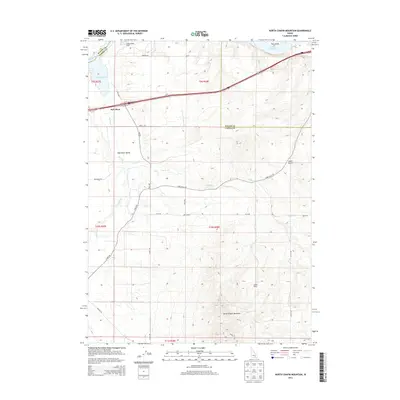
2013 Map of North Chapin Mountain
USGS Topo · Published 2013About this map
Lake Walcott and the Snake River define the northern reaches of this Idaho landscape, where the water meets the arid heights of North Chapin Mountain. The map details a transition from the riparian environment of the Raft River Valley to the higher, furrowed terrain of Lanes Gulch. Local ranching history is evidenced by several named family outposts, including Fenstermaker Ranch, Rehn Ranch, and Jensen Ranch, which are situated along a network of section roads like Lane Gulch RD. Of particular interest to historians is the documented path of the Emigrant Trl, which skirts the western edge of the quadrangle near the Raft River settlement. This corridor preserves the physical alignment of early western migration through Cassia Co and into neighboring Blaine Co.
Find a feature on this map
33 named features on this map. Tap any name to fly to it.
Don’t see what you’re looking for? This feature index may not catch every label — zoom into the map to look around manually.
Map Details
Editions of this 2013 North Chapin Mountain Map
This is the sole edition of this map. No revisions or reprints were ever made.
Other maps of this area

1954 · Pocatello
USGS Topo · 1:250,000

1958 · Pocatello
USGS Topo · 1:250,000

1958 · Sublett
USGS Topo · 1:62,500

1959 · Lake Walcott
USGS Topo · 1:62,500

1959 · Yale
USGS Topo · 1:62,500

1968 · Malta NE
USGS Topo · 1:24,000
1984 · Gifford Spring
USGS Topo · 1:24,000
1984 · Register Rock
USGS Topo · 1:24,000

1984 · North Chapin Mountain
USGS Topo · 1:24,000
1984 · Badger Peak
USGS Topo · 1:24,000