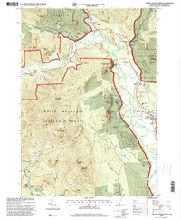
1995 Map of North Conway West
USGS Topo · Published 2000About this map
The Saco River valley and the surrounding peaks of the White Mountain National Forest define this region of New Hampshire at the close of the twentieth century. The map centers on the townships of Bartlett and Albany, where the tourism and recreation economy is evident through features like the Intervale Ski Area, an Amusement Park, and the Conway Scenic Railroad. Cultural and historical markers include several named railroad crossings such as Blackberry Crossing and Cooks Crossing, alongside a Covered Bridge over the Swift River. Significant natural landmarks like Cathedral Ledge and White Horse Ledge overlook the valley, anchoring the Echo Lake-Cathedral Ledge State Park. This survey documents a landscape where traditional settlements like North Conway and Lower Bartlett interface with extensive public forest lands and a complex network of recreation trails, including the Boulder Loop Trail and the Moat Mountain Trail.
Find a feature on this map
60 named features on this map. Tap any name to fly to it.
Don’t see what you’re looking for? This feature index may not catch every label — zoom into the map to look around manually.
Map Details
Editions of this 1995 North Conway West Map
This is the sole edition of this map. No revisions or reprints were ever made.
Other maps of this area

1894 · North Conway
USGS Topo · 1:62,500

1895 · Crawford Notch
USGS Topo · 1:62,500

1896 · Crawford Notch
USGS Topo · 1:62,500

1896 · North Conway
USGS Topo · 1:62,500

1930 · Ossipee Lake
USGS Topo · 1:62,500

1931 · Mt. Chocorua
USGS Topo · 1:62,500

1942 · North Conway
USGS Topo · 1:62,500

1945 · North Conway
USGS Topo · 1:62,500

1946 · Crawford Notch
USGS Topo · 1:62,500

1949 · Portland
USGS Topo · 1:250,000