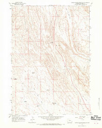
1966 Map of North Emblem Reservoir
USGS Topo · Published 1970About this map
North Emblem Reservoir and its surrounding high plains are defined by an intricate network of irrigation and water storage systems crucial to the local landscape during the mid-1960s. These man-made features, including Cleopatra Reservoir, Caesar Reservoir, and Rolston Reservoir, illustrate the systematic management of water in Big Horn County to support ranching or industrial activities. The terrain is further characterized by the presence of energy extraction, shown through scattered Oil Wells and a significant Pipeline corridor cutting across the topography.
Find a feature on this map
16 named features on this map. Tap any name to fly to it.
Don’t see what you’re looking for? This feature index may not catch every label — zoom into the map to look around manually.
Map Details
Editions of this 1966 North Emblem Reservoir Map
3 editions found
Other maps of this area

1955 · Cody
USGS Topo · 1:250,000

1958 · Cody
USGS Topo · 1:250,000

1962 · Cody
USGS Topo · 1:250,000

1964 · Kane
USGS Topo · 1:24,000

1964 · Lovell Lakes
USGS Topo · 1:24,000
1966 · Sheep Canyon
USGS Topo · 1:24,000

1966 · North Emblem Reservoir
USGS Topo · 1:24,000

1966 · Jack Horner Reservoir
USGS Topo · 1:24,000

1966 · Emblem SE
USGS Topo · 1:24,000
1966 · Lovell
USGS Topo · 1:24,000