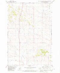
1980 Map of North Fork Crooked Creek East
USGS Topo · Published 1980About this map
Hoskin Basin dominates the southwestern portion of this Yellowstone County landscape, where the seasonal drainage systems of the North Fork and South Fork converge. During the late 1970s and early 1980s, this area of Montana was characterized by an expansive network of intermittent streams, including West Fork, Razor Creek, and the primary channel of Crooked Creek flowing through the southern sections. The map reveals a sparsely populated terrain primarily dedicated to resource extraction and transit, evidenced by several scattered Well sites and the prominent Twentyone Mile Road that bisects the northern half of the quadrangle. This survey serves as a clear record of the rural infrastructure and hydrological patterns of the high plains before further modernization, emphasizing the importance of water access and rudimentary road networks in this arid region.
Find a feature on this map
9 named features on this map. Tap any name to fly to it.
Don’t see what you’re looking for? This feature index may not catch every label — zoom into the map to look around manually.
Map Details
Editions of this 1980 North Fork Crooked Creek East Map
This is the sole edition of this map. No revisions or reprints were ever made.
Other maps of this area

1893 · Huntley
USGS Topo · 1:125,000

1954 · Billings
USGS Topo · 1:250,000

1954 · Roundup
USGS Topo · 1:250,000

1956 · Rattlesnake Butte
USGS Topo · 1:24,000

1956 · Hickson Ranch
USGS Topo · 1:24,000

1956 · Huntley
USGS Topo · 1:24,000

1957 · Billings
USGS Topo · 1:250,000

1958 · Billings
USGS Topo · 1:250,000

1958 · Roundup
USGS Topo · 1:250,000

1979 · Roundup
USGS Topo · 1:100,000