
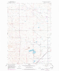
1956 Map of Rattlesnake Butte
USGS Topo · Published 1957About this map
The rugged topography of Rattlesnake Butte overlooks a highly engineered landscape in the mid-1950s, defined by the irrigation infrastructure of the BBWA Canal. The map reveals a complex network of water management features including the Twelvemile Siphon, Crooked Creek Siphon, and an Aqueduct, all supporting the agricultural development of Yellowstone County. A Levee contains the waters of the Rattlesnake Reservoir, while the surrounding terrain is etched with numerous ditches following the natural contours of Crooked Creek and Twelvemile Creek.
Find a feature on this map
22 named features on this map. Tap any name to fly to it.
Don’t see what you’re looking for? This feature index may not catch every label — zoom into the map to look around manually.
Map Details
Editions of this 1956 Rattlesnake Butte Map
2 editions found
Other maps of this area

1893 · Huntley
USGS Topo · 1:125,000

1954 · Billings
USGS Topo · 1:250,000

1954 · Roundup
USGS Topo · 1:250,000

1956 · Hickson Ranch
USGS Topo · 1:24,000

1956 · Huntley
USGS Topo · 1:24,000

1956 · Billings East
USGS Topo · 1:24,000

1957 · Billings
USGS Topo · 1:250,000

1957 · Billings West
USGS Topo · 1:24,000

1958 · Billings
USGS Topo · 1:250,000

1958 · Roundup
USGS Topo · 1:250,000