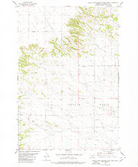
1980 Map of North Fork Crooked Creek West
USGS Topo · Published 1980About this map
Hoskin Basin dominates this 1980 survey of the Montana high plains, characterized by the drainage networks of the North Fork Crooked Creek and South Fork Crooked Creek. The landscape is defined by its agricultural and ranching utility, with the Schultz Ranch and numerous scattered wells marking the human footprint across the terrain. A historical anchor for the area is the Hoskin Basin Cem, located along the route of the Twentyone Mile Road. The map illustrates a transitional period in land management, where traditional grazing lands are intersected by modern infrastructure, such as the Pipeline running north-south near the center of the sheet. Transportation is largely limited to sections of Alexander Road and other unimproved routes that follow the natural topography of the basin and its surrounding slopes.
Find a feature on this map
13 named features on this map. Tap any name to fly to it.
Don’t see what you’re looking for? This feature index may not catch every label — zoom into the map to look around manually.
Map Details
Editions of this 1980 North Fork Crooked Creek West Map
This is the sole edition of this map. No revisions or reprints were ever made.
Other maps of this area

1893 · Huntley
USGS Topo · 1:125,000

1954 · Billings
USGS Topo · 1:250,000

1954 · Roundup
USGS Topo · 1:250,000

1956 · Rattlesnake Butte
USGS Topo · 1:24,000

1956 · Acton
USGS Topo · 1:24,000

1956 · Hickson Ranch
USGS Topo · 1:24,000

1957 · Billings
USGS Topo · 1:250,000

1958 · Billings
USGS Topo · 1:250,000

1958 · Roundup
USGS Topo · 1:250,000

1979 · Roundup
USGS Topo · 1:100,000