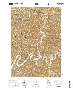
2020 Map of North Fork
USGS Topo · Published 2020About this map
The Smith River meanders deeply through this section of the Siuslaw National Forest, where the confluence with the North Fork Smith River marks the central drainage system of the Coast Range. The landscape is defined by its dramatic topographic relief, featuring high points such as Henderson Peak and Buzzards Butte, alongside numerous named drainages like Russian John Gulch and Horse Gulch. This 2020 survey reveals a remote timber and conservation landscape managed primarily by the Forest Service and the Bureau of Land Management, as evidenced by the dense network of forestry roads including BLM Rd 13 0 and Little Burma Rd. Near the sharpest oxbow of the river, the Lower Smith River Cem stands as a significant genealogical marker for the early settlers of this isolated river valley. The border between Lane and Douglas counties bisects the northern reaches of the map near Robinson Ridge.
Find a feature on this map
47 named features on this map. Tap any name to fly to it.
Don’t see what you’re looking for? This feature index may not catch every label — zoom into the map to look around manually.
Map Details
Editions of this 2020 North Fork Map
This is the sole edition of this map. No revisions or reprints were ever made.
Other maps of this area

1919 · Earl
USGS Topo · 1:48,000

1920 · Siltcoos Lake
USGS Topo · 1:62,500

1923 · Reedsport
USGS Topo · 1:62,500

1941 · Siltcoos Lake
USGS Topo · 1:62,500

1942 · Siltcoos Lake
USGS Topo · 1:62,500

1942 · Reedsport
USGS Topo · 1:62,500

1943 · Goodwin Peak
USGS Topo · 1:62,500

1954 · Coos Bay
USGS Topo · 1:250,000

1955 · Scottsburg
USGS Topo · 1:62,500
1956 · Reedsport
USGS Topo · 1:62,500