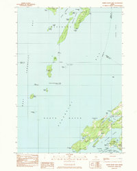
1983 Map of North Haven West
USGS Topo · Published 1983About this map
North Haven Island and the southern reaches of Islesboro anchor this coastal survey, illustrating the complex maritime geography of West Penobscot Bay in the early 1980s. The landscape is defined by its indented shoreline, where deep inlets like Pulpit Harbor and Bartlett Harbor provided natural shelter for the island's maritime community. On the northern shore of North Haven, the local genealogy is preserved at Fuller Cem, while the interior is marked by elevations like Ames Knob and a network of local thoroughfares including Main Road and North Road.
Find a feature on this map
69 named features on this map. Tap any name to fly to it.
Don’t see what you’re looking for? This feature index may not catch every label — zoom into the map to look around manually.
Map Details
Editions of this 1983 North Haven West Map
This is the sole edition of this map. No revisions or reprints were ever made.
Other maps of this area

1902 · Castine
USGS Topo · 1:62,500

1904 · Castine
USGS Topo · 1:62,500

1904 · Vinalhaven
USGS Topo · 1:62,500

1904 · Rockland
USGS Topo · 1:62,500

1905 · Penobscot Bay
USGS Topo · 1:125,000

1906 · Rockland
USGS Topo · 1:62,500

1915 · Belfast
USGS Topo · 1:62,500

1917 · Belfast
USGS Topo · 1:62,500

1941 · Belfast
USGS Topo · 1:62,500

1941 · Rockland
USGS Topo · 1:62,500