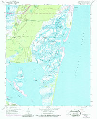
1942 Map of North Island
USGS Topo · Published 1986About this map
Bellefield Plantation and Friendfield stand as prominent landmarks on the southern end of Waccamaw Neck, where the land meets the intricate tidal network of Waccamaw River. This coastal landscape is dominated by the sprawling expanse of North Island, separated from the mainland by a complex system of waterways including Town Creek and Old Man Creek. The 1942 survey detail reveals a transition from the structured grounds of historic plantations to the wilder, shifting sand dunes of Debidue Beach and Long Bay. A labyrinth of tidal channels like Bread and Butter Creek and No Mans Friend Cr underscores the nautical complexity of the region before significant modern development. Further inland, small community markers like Denny Corner and Caines provide critical points of reference for local historians studying the mid-century settlement patterns of Georgetown County.
Find a feature on this map
56 named features on this map. Tap any name to fly to it.
Don’t see what you’re looking for? This feature index may not catch every label — zoom into the map to look around manually.
Map Details
Editions of this 1942 North Island Map
3 editions found
Other maps of this area

1942 · Santee Point
USGS Topo · 1:24,000

1942 · North Island
USGS Topo · 1:24,000

1942 · Magnolia Beach
USGS Topo · 1:24,000

1942 · Waverly Mills
USGS Topo · 1:24,000

1943 · Georgetown North
USGS Topo · 1:24,000

1943 · Minim Island
USGS Topo · 1:24,000

1943 · Georgetown South
USGS Topo · 1:24,000

1947 · Georgetown South
USGS Topo · 1:24,000

1949 · Georgetown
USGS Topo · 1:250,000

1967 · Georgetown
USGS Topo · 1:250,000