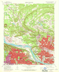
1961 Map of North Little Rock
USGS Topo · Published 1971About this map
Camp Joseph T Robinson dominates the northern landscape of this survey, serving as a significant National Guard training area with its own National Guard Airport and a network of training ranges across Purdham Hill. The Arkansas River serves as the central geographic divider, bridged by the Missouri Pacific and Chicago Rock Island and Pacific railroads. On the north bank, the urban development of North Little Rock and Levy shows dense residential growth, while the south bank features the historic neighborhoods of Pulaski Heights and the independent enclave of Cammack Village. Institutional history is prominent, from the sprawling Fort Roots Veterans Administration Hospital on Big Rock Mountain to several specialized schools like the School for Deaf and School for Blind. The map also captures the early stages of the river's navigation improvements at Lock and Dam No 7.
Find a feature on this map
85 named features on this map. Tap any name to fly to it.
Don’t see what you’re looking for? This feature index may not catch every label — zoom into the map to look around manually.
Map Details
Editions of this 1961 North Little Rock Map
4 editions found
Other maps of this area

1891 · Little Rock
USGS Topo · 1:125,000

1893 · Little Rock
USGS Topo · 1:125,000

1935 · Mc Almont
USGS Topo · 1:24,000

1935 · Little Rock
USGS Topo · 1:24,000

1935 · Sweet Home
USGS Topo · 1:24,000

1935 · North Little Rock
USGS Topo · 1:24,000

1935 · Alexander
USGS Topo · 1:48,000

1941 · Alexander
USGS Topo · 1:62,500

1941 · Olmstead
USGS Topo · 1:31,680

1943 · Pinnacle Mtn
USGS Topo · 1:31,680