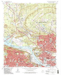
1986 Map of North Little Rock
USGS Topo · Published 1986About this map
The Arkansas River serves as the central artery for this mid-1980s urban and military landscape, separating Little Rock and North Little Rock. To the north, the sprawling grounds of Camp Joseph T. Robinson and the North Little Rock Municipal Airport dominate the topography alongside Purdham Hill. The map documents a dense network of civic and educational institutions, including the Arkansas School for Blind, Arkansas School for Deaf, and Shorter College.
Find a feature on this map
103 named features on this map. Tap any name to fly to it.
Don’t see what you’re looking for? This feature index may not catch every label — zoom into the map to look around manually.
Map Details
Editions of this 1986 North Little Rock Map
2 editions found
Other maps of this area

1891 · Little Rock
USGS Topo · 1:125,000

1893 · Little Rock
USGS Topo · 1:125,000

1935 · Mc Almont
USGS Topo · 1:24,000

1935 · Little Rock
USGS Topo · 1:24,000

1935 · Sweet Home
USGS Topo · 1:24,000

1935 · North Little Rock
USGS Topo · 1:24,000

1935 · Alexander
USGS Topo · 1:48,000

1941 · Alexander
USGS Topo · 1:62,500

1941 · Olmstead
USGS Topo · 1:31,680

1943 · Pinnacle Mtn
USGS Topo · 1:31,680