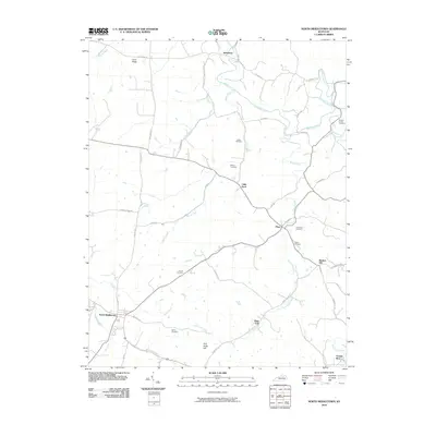
2010 Map of North Middletown
USGS Topo · Published 2010About this map
North Middletown sits at the intersection of a complex rural road network in this Central Kentucky landscape, dominated by the winding paths of Hinkston Creek and Boone Creek. The topography is defined by prominent elevations such as Cane Ridge in the northwest and Five Forks Hill to the south. Historically significant family burial grounds are distributed across the countryside, including the Hayden Young Cemetery near the eastern border and the Bethel Cemetery just outside of town. The settlement pattern follows established routes like Jackstown Rd and Burris Pike, connecting small hamlets such as Jackstown, Little Rock, and Plum. Waterways like Plum Lick Creek and Indian Creek weave through the limestone-based terrain, illustrating the traditional drainage patterns of the Bluegrass region. The map provides a detailed look at the local infrastructure and land divisions that have shaped this community over generations.
Find a feature on this map
47 named features on this map. Tap any name to fly to it.
Don’t see what you’re looking for? This feature index may not catch every label — zoom into the map to look around manually.
Map Details
Editions of this 2010 North Middletown Map
This is the sole edition of this map. No revisions or reprints were ever made.
Other maps of this area

1952 · Sharpsburg
USGS Topo · 1:24,000

1952 · Paris East
USGS Topo · 1:24,000

1952 · Mount Sterling
USGS Topo · 1:24,000

1952 · Austerlitz
USGS Topo · 1:24,000

1952 · North Middletown
USGS Topo · 1:24,000
1952 · Sideview
USGS Topo · 1:24,000

1953 · Carlisle
USGS Topo · 1:24,000

1953 · Moorefield
USGS Topo · 1:24,000

1953 · Millersburg
USGS Topo · 1:24,000

1956 · Louisville
USGS Topo · 1:250,000