
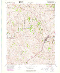
1953 Map of Millersburg
USGS Topo · Published 1954About this map
Hinkston Creek snakes through the center of this Kentucky landscape, defining the rural character of Bourbon, Harrison, and Nicholas Counties in the early 1950s. The settlement of Millersburg serves as a primary hub, characterized by the prominent Millersburg Military Institute and its proximity to the Louisville and Nashville railroad line. This corridor was a vital artery for the region's agricultural economy, connecting small communities like Hooktown and Colville to larger markets.
Find a feature on this map
31 named features on this map. Tap any name to fly to it.
Don’t see what you’re looking for? This feature index may not catch every label — zoom into the map to look around manually.
Map Details
Editions of this 1953 Millersburg Map
2 editions found
Other maps of this area

1927 · Lexington
USGS Topo · 1:48,000

1929 · Cynthiana
USGS Topo · 1:48,000

1929 · Lexington
USGS Topo · 1:62,500

1934 · Cynthiana
USGS Topo · 1:62,500

1952 · Paris East
USGS Topo · 1:24,000

1952 · North Middletown
USGS Topo · 1:24,000

1952 · Piqua
USGS Topo · 1:24,000

1952 · Shady Nook
USGS Topo · 1:24,000

1953 · Carlisle
USGS Topo · 1:24,000
1953 · Cynthiana
USGS Topo · 1:24,000