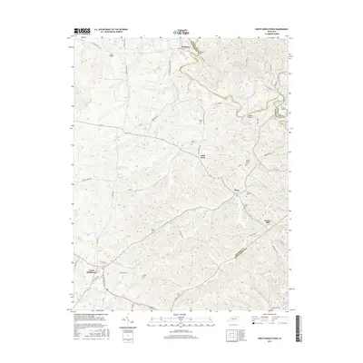
2016 Map of North Middletown
USGS Topo · Published 2016About this map
North Middletown anchors the southwestern corner of this Bluegrass region survey, where the rolling landscape transitions toward the borders of Nicholas and Montgomery counties. This area is defined by its deep genealogical significance, particularly the Edward Boone Grave situated near Boone Creek. The map documents a dense network of family-named burial grounds, including the Hayden Young Cem, Letton Cem, and Wilson Cem, reflecting generations of settlement along the waterways. Drainage patterns are dominated by Hinkston Creek and its many tributaries like Boone Creek and Plum Lick Creek, which carve through the terrain between small hubs such as Little Rock, Plum, and Jackstown. The distribution of these community centers and small cemeteries suggests a long-established rural social structure reliant on the local creek valleys for both transport and territory.
Find a feature on this map
54 named features on this map. Tap any name to fly to it.
Don’t see what you’re looking for? This feature index may not catch every label — zoom into the map to look around manually.
Map Details
Editions of this 2016 North Middletown Map
This is the sole edition of this map. No revisions or reprints were ever made.
Other maps of this area

1952 · Sharpsburg
USGS Topo · 1:24,000

1952 · Paris East
USGS Topo · 1:24,000

1952 · Mount Sterling
USGS Topo · 1:24,000

1952 · Austerlitz
USGS Topo · 1:24,000

1952 · North Middletown
USGS Topo · 1:24,000
1952 · Sideview
USGS Topo · 1:24,000

1953 · Carlisle
USGS Topo · 1:24,000

1953 · Moorefield
USGS Topo · 1:24,000

1953 · Millersburg
USGS Topo · 1:24,000

1956 · Louisville
USGS Topo · 1:250,000