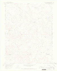
1964 Map of North Mountain
USGS Topo · Published 1968About this map
Hamilton Mesa and Island Mesa dominate this high-altitude landscape along the border of San Miguel and Dolores counties. The 1964 survey reveals a topography defined by complex drainage systems and seasonal high-country outposts like Fall Camp Spring and Jensens Cow Camp. The presence of these named camps suggests the area's continued importance for seasonal livestock grazing during the mid-20th century.
Find a feature on this map
30 named features on this map. Tap any name to fly to it.
Don’t see what you’re looking for? This feature index may not catch every label — zoom into the map to look around manually.
Map Details
Editions of this 1964 North Mountain Map
2 editions found
Other maps of this area

1916 · Paradox Valley
USGS Topo · 1:125,000

1922 · Paradox Valley
USGS Topo · 1:125,000

1956 · Cortez
USGS Topo · 1:250,000

1956 · Moab
USGS Topo · 1:250,000

1958 · Cortez
USGS Topo · 1:250,000

1959 · Cortez
USGS Topo · 1:250,000

1959 · Moab
USGS Topo · 1:250,000

1960 · Moab
USGS Topo · 1:250,000

1962 · Moab
USGS Topo · 1:250,000

1962 · Cortez
USGS Topo · 1:250,000