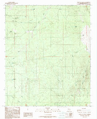
1988 Map of North of Oracle
USGS Topo · Published 1989About this map
Camp Grant Wash and Grant Camp Wash carve through the arid landscape of Pinal County, reflecting a water-reliant geography defined by scattered ranching and mining infrastructure. The terrain rises toward the Black Hills in the northeast, while the southern reaches are marked by the Chirreones Arroyo and Big Wash. This 1980s data, compiled from earlier aerial photography, highlights the critical importance of water management in the desert, noting numerous named features such as Snyder Well, West Well, and Number One Dirt Tank. Evidence of human activity beyond ranching appears in the north with a Mine Shaft near Bloodsucker Wash and a remote Landing Strip. The network of 4wd tracks, Pipeline, and Trans Line corridors suggests a landscape managed for utility and transport across the undulating desert floor.
Find a feature on this map
33 named features on this map. Tap any name to fly to it.
Don’t see what you’re looking for? This feature index may not catch every label — zoom into the map to look around manually.
Map Details
Editions of this 1988 North of Oracle Map
This is the sole edition of this map. No revisions or reprints were ever made.
Other maps of this area

1911 · Winkelman
USGS Topo · 1:125,000

1913 · Winkelman
USGS Topo · 1:125,000

1948 · Mammoth
USGS Topo · 1:62,500

1948 · Mammoth
USGS Topo · 1:24,000

1948 · Campo Bonito
USGS Topo · 1:24,000

1949 · Mammoth
USGS Topo · 1:24,000

1949 · Campo Bonito
USGS Topo · 1:24,000

1949 · Holy Joe Peak
USGS Topo · 1:62,500

1949 · Winkelman
USGS Topo · 1:62,500

1949 · Black Mountain
USGS Topo · 1:24,000