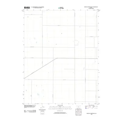
2009 Map of North of Pierceville
USGS Topo · Published 2009About this map
Finney County’s high plains landscape north of Pierceville is defined by a rigorous section-line grid that organizes the rural territory for agricultural use. The primary diagonal artery of E Kansas Ave cuts across the lower-left corner of the map, serving as a rare departure from the strict cardinal orientation of the surrounding local roads. These north-south routes, including N Scott Rd, N Sherman Rd, and N Mennonite Rd, delineate large tracts of land where scattered farmsteads are indicated by small rectangular building footprints. The naming of N Little Mennonite Rd suggests the local cultural history and community settlement patterns of the region. Apart from the road network and isolated structures, the terrain is punctuated only by occasional ephemeral water bodies and the horizontal corridors of E Seven Mile Rd and E Six Mile Rd, reflecting the expansive and open character of the Kansas prairie during the early 21st century.
Find a feature on this map
14 named features on this map. Tap any name to fly to it.
Don’t see what you’re looking for? This feature index may not catch every label — zoom into the map to look around manually.
Map Details
Editions of this 2009 North of Pierceville Map
This is the sole edition of this map. No revisions or reprints were ever made.
Other maps of this area

1896 · Garden
USGS Topo · 1:125,000

1944 · Tennis
USGS Topo · 1:62,500

1955 · Dodge City
USGS Topo · 1:250,000

1955 · Scott City
USGS Topo · 1:250,000

1958 · Dodge City
USGS Topo · 1:250,000

1958 · Scott City
USGS Topo · 1:250,000

1959 · Dodge City
USGS Topo · 1:250,000

1960 · Garden City East
USGS Topo · 1:24,000

1967 · Pierceville
USGS Topo · 1:24,000
1968 · Pierceville NE
USGS Topo · 1:24,000