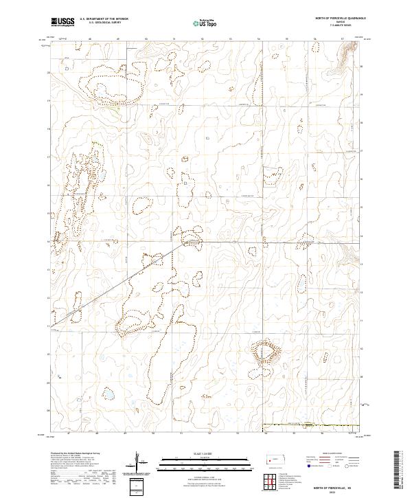
2022 Map of North of Pierceville
USGS Topo · Published 2022About this map
The High Plains landscape of Finney County and Gray County is defined here by a rigid section-line road network and a scattering of ephemeral wetlands. This portion of southwest Kansas is characterized by its agricultural geometry, where major corridors like E Kansas Ave cut through the township and range system. Local transit and land management are anchored by long, straight thoroughfares such as N Scott Rd and N Mennonite Rd, reflecting the heritage of the families and communities who settled this semi-arid prairie. The border between the two counties is marked by Gray Co Line Rd, while the naming of N Little Mennonite Rd suggests the distinct cultural and religious enclaves that established the region's farming foundations. Water remains the most critical variable, visible in the numerous small, unnamed basins that pepper the terrain between E Seven Mile Rd and E Lowe Rd.
Find a feature on this map
22 named features on this map. Tap any name to fly to it.
Don’t see what you’re looking for? This feature index may not catch every label — zoom into the map to look around manually.
Map Details
Editions of this 2022 North of Pierceville Map
This is the sole edition of this map. No revisions or reprints were ever made.
Other maps of this area

1896 · Garden
USGS Topo · 1:125,000

1944 · Tennis
USGS Topo · 1:62,500

1955 · Dodge City
USGS Topo · 1:250,000

1955 · Scott City
USGS Topo · 1:250,000

1958 · Dodge City
USGS Topo · 1:250,000

1958 · Scott City
USGS Topo · 1:250,000

1959 · Dodge City
USGS Topo · 1:250,000

1960 · Garden City East
USGS Topo · 1:24,000

1967 · Pierceville
USGS Topo · 1:24,000
1968 · Pierceville NE
USGS Topo · 1:24,000