
1955 Map of North Of Port Isabel
USGS Topo · Published 1957About this map
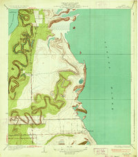
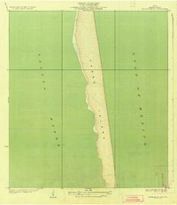
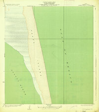
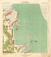
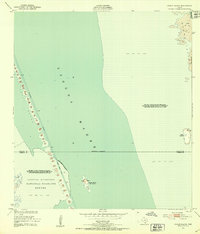
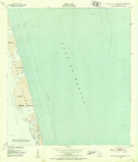
Padre Island serves as the dominant landform on this mid-century coastal survey, separating the shallow, wind-swept Laguna Madre from the open waters of the Gulf of Mexico. The barrier island's surface is characterized by active geomorphology, specifically noted as Shifting Sand Dunes that reach elevations of 23 feet. Human presence in this environment is sparse, indicated primarily by a singular Fence crossing the island and a few isolated named points such as Los Bancos de en Medio, Los Tanques, and La Punta Larga. These small landmarks provide vital orientation points in a landscape of sand and scrub, reflecting the area's remote character before major modern developments altered the South Texas coastline. The boundary between Willacy Co and Cameron Co cuts across the island, marking a political division in an otherwise continuous stretch of shifting sands.
Find a feature on this map
11 named features on this map. Tap any name to fly to it.
Don’t see what you’re looking for? This feature index may not catch every label — zoom into the map to look around manually.
Map Details
Editions of this 1955 North Of Port Isabel Map
This is the sole edition of this map. No revisions or reprints were ever made.
Other maps of this area

1929 · La Coma
USGS Topo · 1:24,000

1929 · Buena Vista
USGS Topo · 1:24,000

1930 · Padre Island No. 1
USGS Topo · 1:24,000

1930 · Padre Island No. 2
USGS Topo · 1:24,000
1934 · La Coma
USGS Topo · 1:31,680
1935 · Padre Island No 1
USGS Topo · 1:31,680
1935 · Padre Island NO. 2
USGS Topo · 1:31,680
1935 · Buena Vista
USGS Topo · 1:31,680
1952 · Green Island
USGS Topo · 1:24,000
1952 · North Of Port Isabel NW
USGS Topo · 1:24,000