
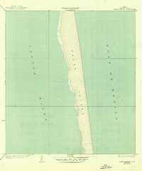
1935 Map of Padre Island No 1
USGS Topo · Published 1935About this map
Padre Island stretches in a narrow, uninterrupted band between the open waters of the Gulf of Mexico and the shallow expanse of the Laguna Madre in this mid-1930s survey of the South Texas coast. Compiled from aerial photographs by the Army Air Corps, the map captures the primitive state of the barrier island before significant modern development or causeway construction. The document highlights the work of Cameron County officials, including County Judge O.C. Dancy and County Engineer W.O. Washington, reflecting the local administration’s focus on mapping these coastal reaches. The survey serves as a clean record of the island's natural shoreline and the intricate, shifting western edge where the island meets the lagoon.
Find a feature on this map
3 named features on this map. Tap any name to fly to it.
Don’t see what you’re looking for? This feature index may not catch every label — zoom into the map to look around manually.
Map Details
Editions of this 1935 Padre Island No 1 Map
2 editions found
Other maps of this area

1929 · La Coma
USGS Topo · 1:24,000

1929 · Point Isabel
USGS Topo · 1:24,000

1929 · Buena Vista
USGS Topo · 1:24,000

1929 · Laguna Vista
USGS Topo · 1:24,000

1930 · Padre Island No. 1
USGS Topo · 1:24,000

1930 · Padre Island No. 2
USGS Topo · 1:24,000

1934 · Port Isabel
USGS Topo · 1:31,680

1934 · La Coma
USGS Topo · 1:31,680

1935 · Padre Island NO. 2
USGS Topo · 1:31,680

1935 · Buena Vista
USGS Topo · 1:31,680