
1935 Map of Padre Island NO. 2
USGS Topo · Published 1935About this map
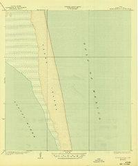
Padre Island stretches across this coastal survey, appearing in its pre-development state during the mid-1930s. This specific section of the barrier island reveals the shifting relationship between the open Gulf of Mexico and the shallow, expansive waters of the Laguna Madre. The map was compiled using aerial photography from the U.S. Army Air Corps, reflecting a period when modern surveying was beginning to utilize flight to chart the dynamic Texas coastline. With no roads, structures, or bridges shown, the sheet emphasizes the natural geography of the region as it was before it became a major recreational destination. The work of W. O. Washington, County Engineer, and the Cameron County Commissioners provided the local control for this federally published record, documenting the pristine shoreline and tidal flats of south Texas.
Find a feature on this map
3 named features on this map. Tap any name to fly to it.
Don’t see what you’re looking for? This feature index may not catch every label — zoom into the map to look around manually.
Map Details
Editions of this 1935 Padre Island NO. 2 Map
2 editions found
Other maps of this area

1929 · La Coma
USGS Topo · 1:24,000

1929 · Buena Vista
USGS Topo · 1:24,000

1930 · Padre Island No. 1
USGS Topo · 1:24,000

1930 · Padre Island No. 2
USGS Topo · 1:24,000

1934 · La Coma
USGS Topo · 1:31,680

1935 · Padre Island No 1
USGS Topo · 1:31,680

1935 · Buena Vista
USGS Topo · 1:31,680

1952 · Green Island
USGS Topo · 1:24,000
1952 · North Of Port Isabel NW
USGS Topo · 1:24,000

1953 · Brownsville
USGS Topo · 1:250,000