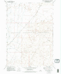
1973 Map of North Of Ryegrass Flat
USGS Topo · Published 1995About this map
The Idaho National Engineering Laboratory dominates this high-desert landscape in Butte County, reflecting a period of intense federal research and nuclear development in the early 1970s. The terrain is defined by dramatic geologic shifts, including the Big Lost River Sinks and Little Lost River Sinks, where surface water disappears into the subterranean basalt. This endorheic drainage pattern is a hallmark of the Snake River Plain, creating a specialized environment for the lab's remote operations.
Find a feature on this map
10 named features on this map. Tap any name to fly to it.
Don’t see what you’re looking for? This feature index may not catch every label — zoom into the map to look around manually.
Map Details
Editions of this 1973 North Of Ryegrass Flat Map
2 editions found
Other maps of this area

1955 · Idaho Falls
USGS Topo · 1:250,000

1958 · Idaho Falls
USGS Topo · 1:250,000

1969 · Little Lost River Sinks
USGS Topo · 1:24,000

1969 · Circular Butte
USGS Topo · 1:24,000

1969 · Big Lost River Sinks
USGS Topo · 1:24,000

1973 · Little Butte NW
USGS Topo · 1:24,000

1973 · Circular Butte 3 NE
USGS Topo · 1:24,000

1973 · Circular Butte 3 SW
USGS Topo · 1:24,000

1973 · Circular Butte 3 SE
USGS Topo · 1:24,000

1973 · Little Butte SW
USGS Topo · 1:24,000