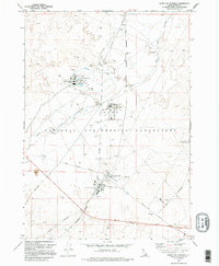
1973 Map of North Of Scoville
USGS Topo · Published 1995About this map
The Idaho National Engineering Laboratory dominates this high-desert landscape in the early 1970s, showcasing a highly specialized industrial and scientific infrastructure. This facility-rich environment is defined by its nuclear research purpose, containing the Test Reactor Area, a large Chemical Plant, and the SPERT (Special Power Excursion Reactor Test) installation. These secure zones are linked by an extensive internal network including Lincoln Boulevard and the U S Government Railroad.
Find a feature on this map
33 named features on this map. Tap any name to fly to it.
Don’t see what you’re looking for? This feature index may not catch every label — zoom into the map to look around manually.
Map Details
Editions of this 1973 North Of Scoville Map
2 editions found
Other maps of this area

1955 · Idaho Falls
USGS Topo · 1:250,000

1958 · Idaho Falls
USGS Topo · 1:250,000

1972 · Arco Hills SE
USGS Topo · 1:24,000

1972 · Big Southern Butte
USGS Topo · 1:24,000

1972 · Howe Peak
USGS Topo · 1:24,000

1973 · Scoville
USGS Topo · 1:24,000

1973 · Circular Butte 3 NE
USGS Topo · 1:24,000

1973 · Atomic City
USGS Topo · 1:24,000

1973 · Circular Butte 3 SW
USGS Topo · 1:24,000

1973 · Circular Butte 3 SE
USGS Topo · 1:24,000