1954 Map of North Pownal
USGS Topo · Published 1980About this map
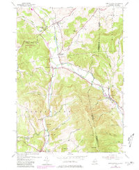
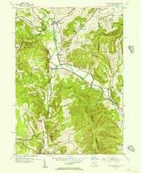
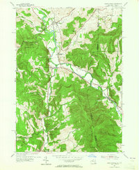
The Hoosic River valley carves through the Taconic Mountains, defining the borderlands of Rensselaer County and Bennington County during the mid-20th century. This area is characterized by narrow hollows such as Breese Hollow and Potter Hollow, where small-scale settlement and agriculture were established between the steep ridges. The industrial and transit identity of the region is anchored by the Boston and Maine railroad, which follows the river course through Petersburg Junction and North Pownal. Local history is preserved in the numerous family and community landmarks, including the Hoosick Cem and the School No 31 Cem. While larger towns like Hoosick and Petersburg appear at the margins, the interior is a landscape of named hills like Moon Hill and Bald Mtn, and conservation efforts are evidenced by the State Reforestation Area in the northwest.
Find a feature on this map
43 named features on this map. Tap any name to fly to it.
Don’t see what you’re looking for? This feature index may not catch every label — zoom into the map to look around manually.
Map Details
Editions of this 1954 North Pownal Map
3 editions found
Other maps of this area

1886 · Greylock
USGS Topo · 1:62,500

1888 · Berlin
USGS Topo · 1:62,500

1890 · Berlin
USGS Topo · 1:62,500

1891 · Greylock
USGS Topo · 1:62,500

1893 · Greylock
USGS Topo · 1:62,500

1894 · Berlin
USGS Topo · 1:62,500

1897 · Hoosick
USGS Topo · 1:62,500

1898 · Berlin
USGS Topo · 1:62,500

1898 · Bennington
USGS Topo · 1:62,500

1898 · Greylock
USGS Topo · 1:62,500