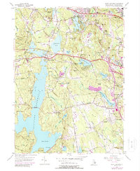
1975 Map of North Scituate
USGS Topo · Published 1988About this map
The vast expanse of the Scituate Reservoir dominates this landscape, held by the Gainer Memorial Dam and crossed by the Ashland Causeway. This mid-1970s record shows the region's complex water management infrastructure, including the Filtration Plant and numerous smaller basins like Moswansicut Pond and Waterman Reservoir. The settlement pattern reflects Rhode Island's historical development along major thoroughfares such as Hartford Pike and Danielson Pike, which converge at North Scituate. Local heritage is preserved in sites like the Scituate Town House and scattered family burial grounds, including Whidding Cem and Colvin Cem. Educational and industrial history is noted at the Waterman Industrial Sch, while the surrounding hills, such as Sickibunkiaut Hill and Peck Hill, define the suburban and rural transition of western Providence County.
Find a feature on this map
87 named features on this map. Tap any name to fly to it.
Don’t see what you’re looking for? This feature index may not catch every label — zoom into the map to look around manually.
Map Details
Editions of this 1975 North Scituate Map
This is the sole edition of this map. No revisions or reprints were ever made.
Other maps of this area

1887 · Providence
USGS Topo · 1:62,500

1889 · Providence
USGS Topo · 1:62,500

1889 · Burrillville
USGS Topo · 1:62,500

1890 · Narragansett Bay
USGS Topo · 1:62,500

1890 · Kent
USGS Topo · 1:62,500

1892 · Narragansett Bay
USGS Topo · 1:62,500

1894 · Burrillville
USGS Topo · 1:62,500

1894 · Kent
USGS Topo · 1:62,500

1894 · Providence
USGS Topo · 1:62,500

1915 · Burrillville
USGS Topo · 1:62,500