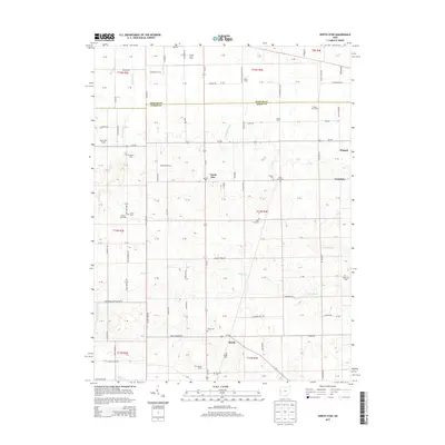
2013 Map of North Star
USGS Topo · Published 2013About this map
The agrarian border between Mercer Co and Darke Co is defined by a dense grid of family agricultural operations and small community centers. North Star serves as a central hub, while the settlements of Osgood, Yorkshire, and Brock anchor the surrounding townships. The landscape is heavily marked by its genealogical record, featuring numerous scattered burial sites such as Saint Louis Cem, Saint Paul Cem, and the Holsapple Cem. Large-scale farming persists through named enterprises like Stucke Grain Farms, Billenstein Farms, and Prairie Star Farms, which are interconnected by a meticulous network of rural roads. Waterways including Mile Cr, Swamp Cr, and the Wabash River wind through the township sections, illustrating the drainage patterns vital to this productive region of western Ohio.
Find a feature on this map
84 named features on this map. Tap any name to fly to it.
Don’t see what you’re looking for? This feature index may not catch every label — zoom into the map to look around manually.
Map Details
Editions of this 2013 North Star Map
This is the sole edition of this map. No revisions or reprints were ever made.
Other maps of this area

1908 · St. Henry
USGS Topo · 1:62,500

1909 · Loramie
USGS Topo · 1:62,500

1911 · Loramie
USGS Topo · 1:62,500

1911 · Covington
USGS Topo · 1:62,500

1944 · Covington
USGS Topo · 1:62,500

1944 · Loramie
USGS Topo · 1:62,500

1953 · Muncie
USGS Topo · 1:250,000

1956 · Muncie
USGS Topo · 1:250,000

1961 · Dawn
USGS Topo · 1:24,000
1961 · Rossburg
USGS Topo · 1:24,000