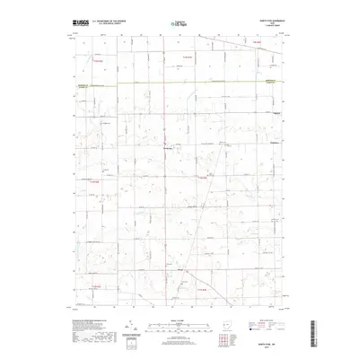
2019 Map of North Star
USGS Topo · Published 2019About this map
The agrarian borderlands of Mercer and Darke counties are captured here, centered on the crossroads of North Star and the nearby villages of Osgood and Yorkshire. This portion of western Ohio is defined by a dense network of country roads, such as US Rte 127 and Main St, which link small farmsteads across the townships of t15n and t12n. The drainage of the upper Wabash River and N Fork Stillwater River is supported by an extensive system of man-made waterways including Ward Ditch and Honsapple Ditch. For those researching local heritage, the map identifies numerous family and parish burial sites, such as Holsapple Cem, Shook Cem, and Saint Louis Cem, which reflect the area's deep-rooted settlement history and agricultural character in the late 2010s.
Find a feature on this map
98 named features on this map. Tap any name to fly to it.
Don’t see what you’re looking for? This feature index may not catch every label — zoom into the map to look around manually.
Map Details
Editions of this 2019 North Star Map
This is the sole edition of this map. No revisions or reprints were ever made.
Other maps of this area

1908 · St. Henry
USGS Topo · 1:62,500

1909 · Loramie
USGS Topo · 1:62,500

1911 · Loramie
USGS Topo · 1:62,500

1911 · Covington
USGS Topo · 1:62,500

1944 · Covington
USGS Topo · 1:62,500

1944 · Loramie
USGS Topo · 1:62,500

1953 · Muncie
USGS Topo · 1:250,000

1956 · Muncie
USGS Topo · 1:250,000

1961 · Dawn
USGS Topo · 1:24,000
1961 · Rossburg
USGS Topo · 1:24,000