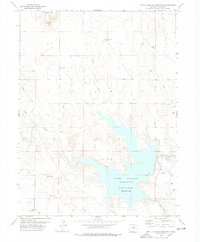
1978 Map of North Sterling Reservoir
USGS Topo · Published 1978About this map
North Sterling Reservoir (Point of Rocks Reservoir) dominates this Logan County landscape, serving as a critical water management feature for the region's agricultural economy. Fed and drained by a complex network including the North Sterling Canal and the North Sterling Outlet, the reservoir's irregular shoreline is punctuated by a massive Spillway and nearby Rodeo Ground. This late 1970s survey illustrates a rural environment where water security and resource extraction coexist, with numerous Oil Wells and a distinct Pipeline cutting across the terrain.
Find a feature on this map
21 named features on this map. Tap any name to fly to it.
Don’t see what you’re looking for? This feature index may not catch every label — zoom into the map to look around manually.
Map Details
Editions of this 1978 North Sterling Reservoir Map
This is the sole edition of this map. No revisions or reprints were ever made.
Other maps of this area

1951 · Sterling North
USGS Topo · 1:24,000

1951 · Wild Horse Lake
USGS Topo · 1:24,000

1951 · Atwood NE
USGS Topo · 1:24,000

1951 · Padroni NW
USGS Topo · 1:24,000

1952 · Padroni
USGS Topo · 1:24,000

1954 · Sterling
USGS Topo · 1:250,000

1958 · Sterling
USGS Topo · 1:250,000
1978 · Kirchnavy Butte
USGS Topo · 1:24,000
1978 · Chimney Canyons
USGS Topo · 1:24,000
1978 · Westplains
USGS Topo · 1:24,000