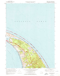
1972 Map of North Truro
USGS Topo · Published 1974About this map
Cape Cod National Seashore dominates this 1970s landscape, protecting a massive stretch of the Outer Cape between Cape Cod Bay and the Atlantic Ocean. The settlement pattern centers on North Truro and Pond Village, where historic roads like Kings Highway and Old County Rd reflect centuries of travel through the shifting dunes and coastal hollows. High above the water, the Highland Light Coast Guard Sta and the North Truro Air Force Station represent the area's strategic importance for both navigation and national defense. Local genealogists will find the Old North Cem and numerous named family landmarks like Smalls Hill and Corn Hill, while the presence of a Bicycle Trail and various campgrounds shows the transition of this maritime environment into a premier recreational destination.
Find a feature on this map
61 named features on this map. Tap any name to fly to it.
Don’t see what you’re looking for? This feature index may not catch every label — zoom into the map to look around manually.
Map Details
Editions of this 1972 North Truro Map
3 editions found
Other maps of this area

1887 · Wellfleet
USGS Topo · 1:62,500

1887 · Provincetown
USGS Topo · 1:62,500

1889 · Provincetown
USGS Topo · 1:62,500

1889 · Wellfleet
USGS Topo · 1:62,500

1893 · Wellfleet
USGS Topo · 1:62,500

1898 · Provincetown
USGS Topo · 1:62,500

1942 · Cape Cod Bay
USGS Topo · 1:125,000

1942 · Nauset
USGS Topo · 1:125,000

1944 · Provincetown
USGS Topo · 1:31,680

1944 · Wellfleet
USGS Topo · 1:31,680