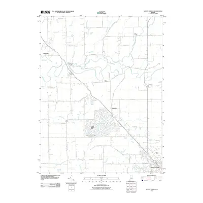
2010 Map of North Vernon
USGS Topo · Published 2010About this map
North Vernon sits at the southeastern corner of this Jennings County survey, where the street grid transitions into a landscape defined by meandering waterways and scattered rural settlements. The sprawling residential development of Country Squire Lakes dominates the central portion of the map, centered around the Country Squire Lake Dam. This modern footprint contrasts with the smaller, more historic clusters at Scipio, Queensville, and Tannersville. A network of creeks, including the winding Sand Creek and Mutton Creek, carve through the terrain, historically dictating the placement of the area's earliest homesteads and crossings.
Find a feature on this map
72 named features on this map. Tap any name to fly to it.
Don’t see what you’re looking for? This feature index may not catch every label — zoom into the map to look around manually.
Map Details
Editions of this 2010 North Vernon Map
This is the sole edition of this map. No revisions or reprints were ever made.
Other maps of this area

1942 · Columbus
USGS Topo · 1:125,000

1953 · Cincinnati
USGS Topo · 1:250,000

1956 · Louisville
USGS Topo · 1:250,000

1957 · Cincinnati
USGS Topo · 1:250,000

1957 · Butlerville
USGS Topo · 1:24,000

1957 · Azalia
USGS Topo · 1:24,000

1957 · North Vernon
USGS Topo · 1:24,000

1958 · Westport
USGS Topo · 1:24,000

1958 · Grammer
USGS Topo · 1:24,000
1958 · Elizabethtown
USGS Topo · 1:24,000