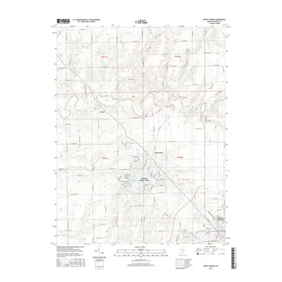
2016 Map of North Vernon
USGS Topo · Published 2016About this map
Scipio and Queensville anchor this survey of northwestern Jennings County, where the landscape is defined by the winding course of Sand Creek. The map documents a transition from the agricultural expanses of the northern townships into the suburban density of Country Squire Lakes and the fringes of North Vernon. This 2016 record captures the modern layout of these communities, showing the residential street patterns of the lakes district alongside historical markers such as Saint Marys Cem and Hulse Cem. A complex network of drainage, including Wyalusing Creek, Sixmile Cr, and Mutton Cr, cuts through the terrain, illustrating how water shapes the settlement patterns and road placements. The detailed street labels in the southern portion, like Bay St and Franklin St, provide high-resolution data for researchers tracing the northern growth of the county seat.
Find a feature on this map
117 named features on this map. Tap any name to fly to it.
Don’t see what you’re looking for? This feature index may not catch every label — zoom into the map to look around manually.
Map Details
Editions of this 2016 North Vernon Map
This is the sole edition of this map. No revisions or reprints were ever made.
Other maps of this area

1942 · Columbus
USGS Topo · 1:125,000

1953 · Cincinnati
USGS Topo · 1:250,000

1956 · Louisville
USGS Topo · 1:250,000

1957 · Cincinnati
USGS Topo · 1:250,000

1957 · Butlerville
USGS Topo · 1:24,000

1957 · Azalia
USGS Topo · 1:24,000

1957 · North Vernon
USGS Topo · 1:24,000

1958 · Westport
USGS Topo · 1:24,000

1958 · Grammer
USGS Topo · 1:24,000
1958 · Elizabethtown
USGS Topo · 1:24,000