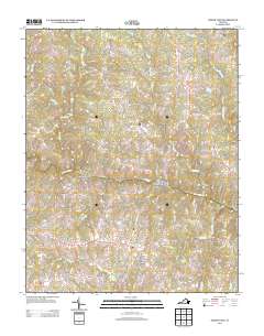
2013 Map of North View
USGS Topo · Published 2013About this map
The Meherrin River carves through the center of this Mecklenburg County landscape, serving as a primary geographical anchor for the surrounding rural communities. Settlement patterns are defined by small nodes at road intersections and historic water-driven sites like Whittles Mill and Bagleys Mills. Transportation relies on a network of named routes such as Plank Rd and Meherrin Rd, which connect long-standing locales including Gary, Ogburn, and Saffolds Bridge. The terrain is deeply etched by a system of tributaries, with Crooked Cr, Miles Cr, and Bears Element Cr feeding into the main river valley. This 2013 survey illustrates the enduring nature of Virginia's Southside rural geography, where family-named landmarks like Russell Corner and Chalk Level remain as persistent markers of local identity and property history.
Find a feature on this map
66 named features on this map. Tap any name to fly to it.
Don’t see what you’re looking for? This feature index may not catch every label — zoom into the map to look around manually.
Map Details
Editions of this 2013 North View Map
This is the sole edition of this map. No revisions or reprints were ever made.
Other maps of this area

1953 · Greensboro
USGS Topo · 1:250,000

1954 · Greensboro
USGS Topo · 1:250,000

1955 · Chase City
USGS Topo · 1:62,500

1955 · Kenbridge
USGS Topo · 1:62,500

1955 · Boydton
USGS Topo · 1:62,500

1962 · Greensboro
USGS Topo · 1:250,000

1966 · Greensboro
USGS Topo · 1:250,000
1966 · Wightman
USGS Topo · 1:24,000
1966 · North View
USGS Topo · 1:24,000
1966 · Lunenburg
USGS Topo · 1:24,000