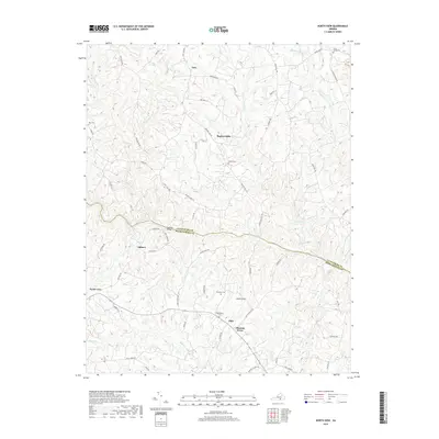
2019 Map of North View
USGS Topo · Published 2019About this map
The Meherrin River defines the jurisdictional boundary between Lunenburg and Mecklenburg counties, anchored by the historical crossing at Saffolds Bridge. This rural Southside Virginia landscape is characterized by a network of small, dispersed communities including North View, Bagleys Mills, and Ogburn. The area maintains a traditional agricultural character, with secondary roads like Plank Rd and Bagleys Mill Rd tracing the high ground between numerous tributaries. Significant family and community landmarks are scattered throughout the quadrangle, such as Saint James Cem and Tabernacle Cem, which serve as vital reference points for local history. Waterways like Piney Cr and Miles Cr carve through the terrain, illustrating the historical importance of drainage and natural boundaries in the development of the region's early settlements like Opie and Chalk Level.
Find a feature on this map
60 named features on this map. Tap any name to fly to it.
Don’t see what you’re looking for? This feature index may not catch every label — zoom into the map to look around manually.
Map Details
Editions of this 2019 North View Map
This is the sole edition of this map. No revisions or reprints were ever made.
Other maps of this area

1953 · Greensboro
USGS Topo · 1:250,000

1954 · Greensboro
USGS Topo · 1:250,000

1955 · Chase City
USGS Topo · 1:62,500

1955 · Kenbridge
USGS Topo · 1:62,500

1955 · Boydton
USGS Topo · 1:62,500

1962 · Greensboro
USGS Topo · 1:250,000

1966 · Greensboro
USGS Topo · 1:250,000
1966 · Wightman
USGS Topo · 1:24,000
1966 · North View
USGS Topo · 1:24,000
1966 · Lunenburg
USGS Topo · 1:24,000