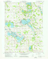
1962 Map of North Webster
USGS Topo · Published 1964About this map
Webster Lake and the Big Barbee Lake chain dominate this mid-century survey of the Indiana lake country. The landscape is defined by its glacial hydrology, with a dense network of water bodies including Sechrist Lake, Irish Lake, and Kuhn Lake connected by the Tippecanoe River. Settlement is concentrated around these shores at North Webster and Epworth Forest, while the surrounding rural townships of Tippecanoe and Washington maintain an agricultural character. The map captures a high concentration of recreational and community landmarks from the early 1960s, such as the Drive-in Theater, Spring Roadside Park, and several youth camps including Camp Crosley and Camp Tippecanoe. For genealogists, the sheet preserves the locations of numerous family and community burial grounds like Mock Cem and Oak Grove Cem, alongside local congregations at Salem Ch and Morris Chapel.
Find a feature on this map
80 named features on this map. Tap any name to fly to it.
Don’t see what you’re looking for? This feature index may not catch every label — zoom into the map to look around manually.
Map Details
Editions of this 1962 North Webster Map
4 editions found
Other maps of this area

1950 · Leesburg
USGS Topo · 1:24,000

1950 · Pierceton
USGS Topo · 1:24,000

1950 · North Webster
USGS Topo · 1:24,000

1951 · Milford
USGS Topo · 1:24,000

1951 · Wawasee
USGS Topo · 1:24,000

1951 · Ormas
USGS Topo · 1:24,000

1953 · Fort Wayne
USGS Topo · 1:250,000

1956 · Fort Wayne
USGS Topo · 1:250,000

1956 · Ligonier
USGS Topo · 1:24,000

1956 · Lorane
USGS Topo · 1:24,000