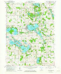
1962 Map of North Webster
USGS Topo · Published 1976About this map
The Tippecanoe River winds through this lake-rich portion of northern Indiana, connecting a dense network of glacial water bodies including Lake Tippecanoe, James Lake, and the expansive Webster Lake. The map details a landscape deeply shaped by recreation and conservation, featuring numerous youth retreats such as Camp Tippecanoe, Camp Dick Runyan, and Camp Crosley. The vast Tri-County State Fish and Game Area dominates the central and northern sections, encompassing smaller basins like Shock Lake and Long Lake. This 1962 revision provides a look at the early development of lakeside communities like North Webster, Indian Village, and Epworth Forest. Beyond the water, the survey identifies several rural landmarks for genealogists, including the Mock Cem and Oak Grove Cem, alongside the Old Indian Treaty Boundary which cuts diagonally across the townships.
Find a feature on this map
76 named features on this map. Tap any name to fly to it.
Don’t see what you’re looking for? This feature index may not catch every label — zoom into the map to look around manually.
Map Details
Editions of this 1962 North Webster Map
4 editions found
Other maps of this area

1950 · Leesburg
USGS Topo · 1:24,000

1950 · Pierceton
USGS Topo · 1:24,000

1950 · North Webster
USGS Topo · 1:24,000

1951 · Milford
USGS Topo · 1:24,000

1951 · Wawasee
USGS Topo · 1:24,000

1951 · Ormas
USGS Topo · 1:24,000

1953 · Fort Wayne
USGS Topo · 1:250,000

1956 · Fort Wayne
USGS Topo · 1:250,000

1956 · Ligonier
USGS Topo · 1:24,000

1956 · Lorane
USGS Topo · 1:24,000