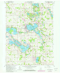
1962 Map of North Webster
USGS Topo · Published 1982About this map
The glacial lakes of northern Indiana dominate this landscape, where the Webster Lake and Big Barbee Lake systems form a dense network of water bodies and recreational grounds. Centered on the town of North Webster, the map illustrates a post-war era of established lakefront life, evidenced by a high density of named camps such as Camp Tippecanoe and Camp Dick Runyan, and the religious retreat at Epworth Forest. The Indian Treaty Boundary cuts diagonally through the northwest, a historical line that still influenced property and township divisions into the 1960s. To the north and east, the Tri-County State Fish and Game Area preserves a more primitive landscape of smaller kettle lakes like Shock Lake and Grindle Lake, contrasting with the more developed residential shorelines of Tippecanoe Lake and James Lake. Local genealogy is anchored by landmarks like Morris Chapel and the Mock Cem.
Find a feature on this map
72 named features on this map. Tap any name to fly to it.
Don’t see what you’re looking for? This feature index may not catch every label — zoom into the map to look around manually.
Map Details
Editions of this 1962 North Webster Map
4 editions found
Other maps of this area

1950 · Leesburg
USGS Topo · 1:24,000

1950 · Pierceton
USGS Topo · 1:24,000

1950 · North Webster
USGS Topo · 1:24,000

1951 · Milford
USGS Topo · 1:24,000

1951 · Wawasee
USGS Topo · 1:24,000

1951 · Ormas
USGS Topo · 1:24,000

1953 · Fort Wayne
USGS Topo · 1:250,000

1956 · Fort Wayne
USGS Topo · 1:250,000

1956 · Ligonier
USGS Topo · 1:24,000

1956 · Lorane
USGS Topo · 1:24,000