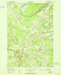
1951 Map of North Wilna
USGS Topo · Published 1951About this map
Pine Camp Military Reservation dominates the landscape of northern New York, occupying a vast portion of the territory between the Indian River and the Jefferson and Lewis County line. The mid-century geography reveals a region of transition, where established rural communities like North Wilna and Lewisburg exist alongside expanding military grounds and artillery training zones such as the Wilna Range. The intersection of industrial history and institutional growth is evident in the presence of Woods Mill and the New York Central railroad, which provided vital transit through this pocket of the North Country.
Find a feature on this map
53 named features on this map. Tap any name to fly to it.
Don’t see what you’re looking for? This feature index may not catch every label — zoom into the map to look around manually.
Map Details
Editions of this 1951 North Wilna Map
This is the sole edition of this map. No revisions or reprints were ever made.
Other maps of this area

1902 · Carthage
USGS Topo · 1:62,500

1904 · Carthage
USGS Topo · 1:62,500

1911 · Antwerp
USGS Topo · 1:62,500

1911 · Lowville
USGS Topo · 1:62,500

1913 · Lowville
USGS Topo · 1:62,500

1913 · Lake Bonaparte
USGS Topo · 1:62,500

1916 · Lake Bonaparte
USGS Topo · 1:62,500

1942 · Copenhagen
USGS Topo · 1:24,000

1943 · Copenhagen
USGS Topo · 1:31,680

1943 · Carthage
USGS Topo · 1:31,680