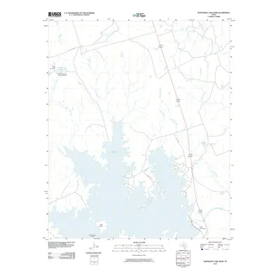
2010 Map of Northeast Lake Kemp
USGS Topo · Published 2010About this map
Lake Kemp dominates the landscape of this Wilbarger County quadrangle, showing the intricate shoreline and surrounding ranching infrastructure of North Texas in the early 21st century. The map captures the significant hydrological footprint of the Wichita River valley, controlled by the Lake Kemp Dam at the southeastern edge of the reservoir. To the northwest, the Coffee Creek Cow Camp and its associated Coffee Creek Cow Camp Lake point to the enduring agricultural and livestock history of the region. A dense network of drainage systems, including East Coffee Creek, Whiskey Creek, and Cattle Creek, feed into the main body of water, defining the local topography. Isolated landmarks like Goat Island and Rattlesnake Island emerge from the reservoir, while local routes such as Coffee Creek Rd and Hotel Rd provide access through the rolling terrain.
Find a feature on this map
22 named features on this map. Tap any name to fly to it.
Don’t see what you’re looking for? This feature index may not catch every label — zoom into the map to look around manually.
Map Details
Editions of this 2010 Northeast Lake Kemp Map
This is the sole edition of this map. No revisions or reprints were ever made.
Other maps of this area

1954 · Wichita Falls
USGS Topo · 1:250,000

1958 · Wichita Falls
USGS Topo · 1:250,000

1966 · Franklin Bend
USGS Topo · 1:24,000

1966 · Fulda
USGS Topo · 1:24,000

1966 · Santa Rosa Lake
USGS Topo · 1:24,000

1966 · Grayback
USGS Topo · 1:24,000
1966 · Lake Electra
USGS Topo · 1:24,000

1966 · Northeast Lake Kemp
USGS Topo · 1:24,000

1966 · Southeast Lake Kemp
USGS Topo · 1:24,000

1966 · Northwest Lake Kemp
USGS Topo · 1:24,000